In brief
- India and China are in an active stand-off along the Line of Actual Control in Arunachal Pradesh's Upper Subansiri district, starting in July 2026 and unresolved by late October 2026.
- Pockets at Asaphila, Maja, Longju, and Pukar La have seen PLA units stray from established patrolling patterns and pitch tents on elevated ground inside India's perception of the LAC.
- Defence officials say no violent clashes have occurred and ground commanders are managing encounters through flag meetings and hotlines.
- A four month period of confrontation evidence came from indigenous Tagin and Nah associations, regional fact-finding teams, and commercial satellite imagery, with public details highlighted in late October 2026.
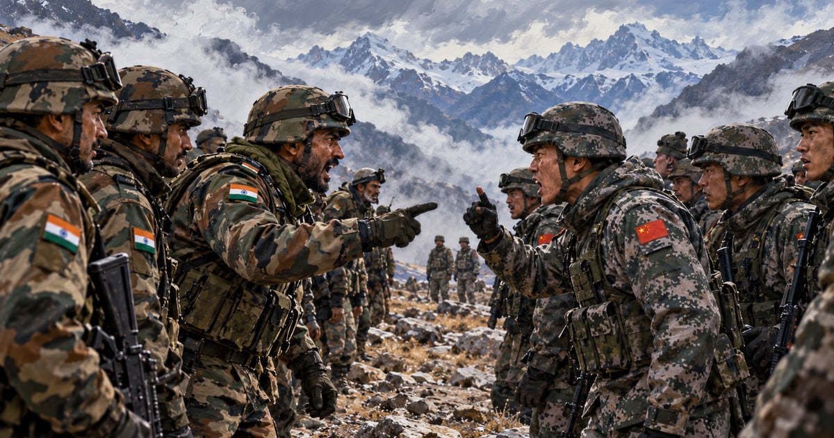
Indian and Chinese security forces are engaged in an active, multi-location stand-off along the Line of Actual Control (LAC) in Arunachal Pradesh that began in July 2026 and remained unresolved as of late October 2026. The friction centres on the remote Taksing circle of Upper Subansiri district—specifically the contested pockets of Asaphila, Maja, Longju, and Pukar La—where People's Liberation Army (PLA) units deviated from established patrolling patterns and pitched tents on elevated ground inside India's perception of the LAC (WION, The Wire). While defence officials state that no violent clashes have taken place and local commanders are managing the encounters through flag meetings and hotlines (India Today), the stand-off marks the most sustained test of India–China border management since the two countries signed their 21 October 2024 patrolling agreement to end the four-year freeze in Eastern Ladakh.
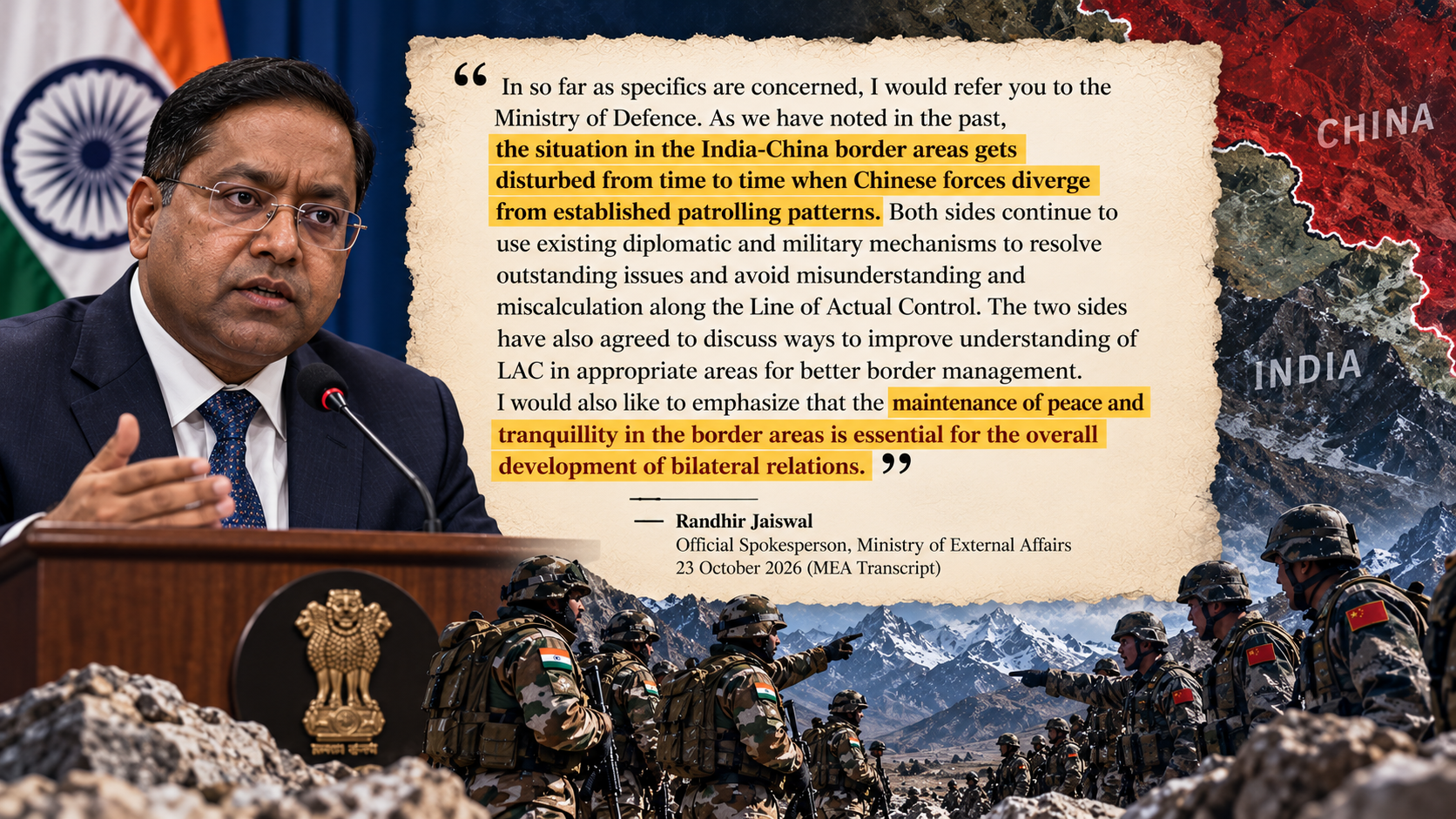
For four months, public evidence of the confrontation in Upper Subansiri came primarily from indigenous Tagin and Nah tribal associations, regional political fact-finding teams, and commercial satellite imagery (TBS News, The Arunachal Times). That changed on 22 October 2026, when Indo-Tibetan Border Police (ITBP) Director General Shatrujeet Singh Kapur publicly acknowledged that face-offs with Chinese troops had occurred at "several locations in Arunachal" and were "still ongoing" (The Financial Express). Twenty-four hours later, Ministry of External Affairs (MEA) spokesperson Randhir Jaiswal confirmed that the frontier "gets disturbed from time to time when Chinese forces diverge from established patrolling patterns" (MEA Media Briefing Transcript, 23 October 2026).
The escalation in the Eastern Sector has unfolded alongside high-level diplomatic normalisation, including Chinese President Xi Jinping's visit to New Delhi for the 18th BRICS Summit on 12–13 September 2026—his first trip to India in seven years (MEA Press Release, 12 September 2026, Lowy Institute). Understanding why tactical pressure has intensified in Arunachal Pradesh just as diplomatic channels reopened requires examining the geography of Upper Subansiri, the operational gap between summer and winter patrolling, and the structural divergence between Beijing's and New Delhi's approaches to the boundary question.
What Official Statements Confirm About the October 2026 Face-Offs
The first official confirmation of the scale of the Arunachal Pradesh stand-off came during an internal paramilitary ceremony rather than a defence ministry briefing. Addressing troops on 22 October 2026 at the Himveer Samman Samaroh at the ITBP Central Training College in Alwar, Rajasthan—held two days before the force's 65th Raising Day—outgoing ITBP Director General Shatrujeet Singh Kapur praised the performance of the force's newly formed high-altitude commando units (The Wire, Daily Pioneer).
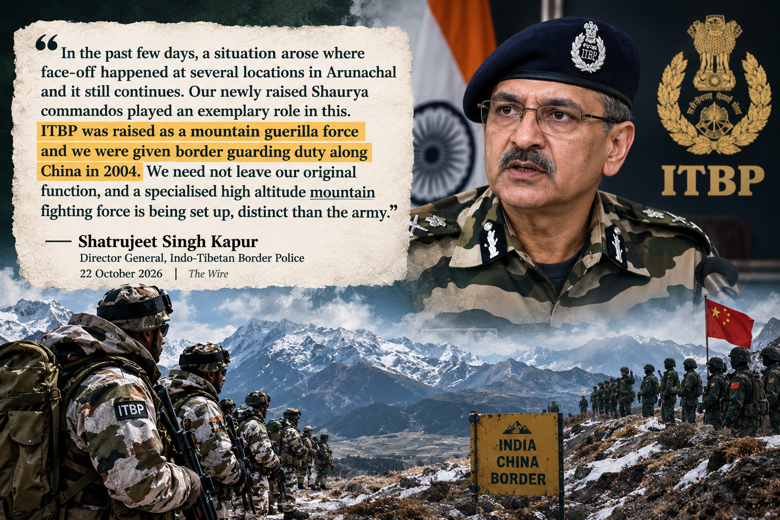
The ITBP initially uploaded video footage of Kapur's Alwar address to X, but removed the video after national newspapers reported his confirmation of continuing stand-offs (Hindustan Times). When journalists pressed the government at the bi-weekly MEA briefing on 23 October 2026 on whether New Delhi had formally raised the Arunachal Pradesh stand-off with Beijing, official spokesperson Randhir Jaiswal declined to provide operational locations, directing tactical queries to the Ministry of Defence while attributing the friction to Chinese patrol movements:
On the morning of 24 October 2026, defence sources briefed reporters that two specific pockets in the Taksing circle—Asaphila and Longju—remain sensitive due to differing perceptions of the LAC, leading to recurring encounters when Indian and Chinese patrols cross paths (India Today). Those sources emphasised that no physical clashes or injuries had occurred and that ground commanders were maintaining operational control through flag meetings and hotlines.
Where the Standoff Is Happening: Asaphila, Maja, Gelemo, and Longju
While Tawang in western Arunachal Pradesh has historically drawn public attention due to the December 2022 Yangtse clash, the 2026 friction is concentrated roughly 250 kilometres further east in Upper Subansiri district, where the Subansiri river and its tributaries cut through the high Himalayas from Tibet into India (The Borderlens). Across the McMahon Line lies Lhunze County in China's Shannan Prefecture of the Tibet Autonomous Region (TBS News).
Five interlocking locations in Upper Subansiri's Taksing and Limeking circles form the geography of the current stand-off:
Asaphila: A contested, heavily forested mountain tract covering roughly 100 square kilometres along the McMahon Line west of Taksing. Because the 1914 Simla Convention map drew the boundary along high watershed ridges without joint ground demarcation, both India and China claim Asaphila and treat opposing patrols as transgressions (Times of India, India Today).
Maja (Maza): The forward-most Indian habitation and security outpost area south of the Longju–Asaphila belt in Taksing circle. According to government sources cited by The Hindu, The Wire, and WION, Indian and Chinese patrols came face-to-face near the Maja company operating base during routine patrolling in late July 2026 (WION, The Wire). After a brief confrontation and banner drill, both sides withdrew, but PLA troops returned in greater strength several days later in early August and pitched tents on higher ground overlooking the approaches near Maja, prompting India to reinforce its forward deployments (ThePrint, The Wire).
Longju: Located immediately north of Maja, Longju was the site of the first armed clash between Indian Assam Rifles personnel and Chinese troops in August 1959, after which India withdrew its forward post (The Borderlens). Over the past five years, China has constructed around 100 modern Xiaokang (well-off) border village structures in the Longju–Zhari sector and expanded all-weather road networks right up to the perceived LAC (TBS News).
Pukar La (Pokorla) and Gelemo: Gelemo is a remote settlement of the indigenous Mra (Mara) and Tagin communities in Taksing circle, located near the 1962 Sher-e-Thapa war memorial (The Borderlens). According to the Gelemo gaon bura (village headman) interviewed by The Arunachal Times in late August 2026, Indian and Chinese troops entered a separate face-off at Pukar La after Chinese soldiers began camping between patrol points CP 5 and CP 6 on 10 July 2026 (The Arunachal Times).
Shera-5, Nanga Pahar (Nonga Hill), and Potrang Lake: Local tribal bodies and a political fact-finding delegation reported that indigenous residents have been barred from accessing Nanga Pahar—traditional yak-grazing and hunting land of the Nah and Mra clans—and that PLA soldiers blocked local Buddhist worshippers from visiting Potrang Lake, a sacred ritual site an hour's walk from Taksing connected to the historic Tsari (Rong Kora) pilgrimage circuit (The Arunachal Times, TBS News). The same fact-finding report alleged that Indian patrols have been unable to reach designated patrolling point Shera-5 since a physical confrontation in 2023, after which PLA forces dismantled Indian markers (The Arunachal Times).
Reconciling Conflicting Accounts: Why Distance Estimates Diverge
A central point of confusion in public reporting between June and October 2026 has been the wide variation in reported depths of Chinese movement—ranging from "no incursion" in official army statements to 2.5 kilometres, 6–7 kilometres, and 15–20 kilometres in media and local reports. Comparing the primary sources side by side clarifies why these figures differ:
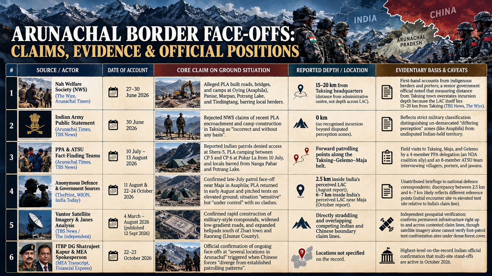
The apparent contradiction between the Nah Welfare Society's "15–20 km from Taksing" figure and defence sources' "2.5 km to 7 km inside the LAC" figure stems from geography rather than fabrication. As reported in The Independent's investigation, the remote villages of Taksing and Gelemo sit 15 to 20 kilometres south of the international border (TBS News). When tribal leaders stated that PLA forces had reached within 15 to 20 kilometres of Taksing headquarters, they were describing activity in the high-altitude grazing belt just south of the McMahon Line—the same 2.5-to-7-kilometre buffer zone near Maja and Asaphila described by Indian security officials.
The Operational Vulnerability: Seasonal Patrolling vs Year-Round Infrastructure
The most consequential finding from the ground investigations in Upper Subansiri is not a single tent encampment, but a structural seasonal asymmetry between how the two militaries operate in the Eastern Himalayas.
Following its 10 July 2026 field inspection of Taksing, Maja, and Gelemo, the four-member fact-finding committee of the People's Party of Arunachal (PPA)—headed by former state minister Kahfa Bengia—documented that regular Indian foot patrolling in the highest reaches of Taksing is largely confined to the seven-month window between April and October (The Arunachal Times). From November to March, heavy snowfall closes high-altitude passes and un-surfaced tracks. Local porters who ferry rations and equipment for Indian patrols told the committee that they are not hired during the winter months, reflecting a sharp seasonal reduction in forward patrol frequency (The Arunachal Times).
Across the watershed in Lhunze County, the geographical terrain on the Tibetan plateau is flatter, drier, and backed by decades of all-weather road construction. Satellite imagery captured by Vantor between October 2022 and August 2026 and analysed by Janes shows how Beijing has converted that geographic advantage into year-round tactical reach (TBS News):
Forward Road Engineering and Helipads (Zhari and Raorang): Between February and May 2026, Chinese engineers completed a new road linking forward sites south of Zhari town, widened existing mountain tracks, and reduced steep gradients so heavy military transport vehicles can operate year-round (TBS News). Two smaller helipads south of Lhunze were consolidated into a larger helipad, with an additional helipad built further south towards the Upper Subansiri border, and roofing completed on suspected military compounds by August 2026 (TBS News).
Airbase Fortification at Lhunze: Deeper behind the Taksing–Tawang frontier, satellite imagery from October 2025 documented 36 hardened aircraft shelters, underground storage, and deployed CH-4 armed reconnaissance drones capable of operating above 4,800 metres (16,000 feet) at Lhunze airbase (Arunachal24).
The Infrastructure Gap in Forward Indian Villages: By contrast, residents and security personnel in Maja and Gelemo told the PPA and ATSU delegations in July and August 2026 that their outposts and villages still lacked grid electricity—relying on diesel generators—and suffered from patchy telephone and mobile data connectivity (The Arunachal Times, TBS News). Villager Takok Mra of Gelemo told The Independent that the absence of reliable roads, electricity, schools, and clinics was driving indigenous families to migrate towards district headquarters such as Daporijo, removing the local herders and hunters who have historically served as the Indian military's early-warning network along the frontier (TBS News).
To close this gap, the state government issued land acquisition notifications in May 2026 for expanded Army infrastructure at Tame Chung Chung, Bidak, Gelemo, and Taksing (The Borderlens), while local representatives have urged the Border Roads Organisation (BRO) to fast-track the Nacho–Taksing highway, build a 68-kilometre road from Gelemo to Pukar La, construct a helipad at Sipi 2, and establish permanent year-round Army base camps at Sipi 4 and Sipi 6 (The Arunachal Times).
How India Is Restructuring the ITBP for High-Altitude Drone and Bunker Warfare
ITBP Director General Shatrujeet Kapur's 22 October 2026 speech in Alwar was notable not only for confirming the Arunachal Pradesh stand-off, but for detailing how the Ministry of Home Affairs (MHA) is overhauling the 3,488-kilometre LAC border-guarding force in response to PLA capabilities (Daily Pioneer, The Wire).
Kapur candidly acknowledged that many of the ITBP's standard-issue infantry weapons are roughly 50 years old and that conventional policing methods cannot match China's heavy investment in its Border Defence Regiments (The Wire, The Financial Express). Over the past year, India has initiated three specific force-posture changes along the China border:
Deployment of Shaurya High-Altitude Commandos: Returning to the ITBP's post-1962 origins as a mountain guerrilla force, the paramilitary has raised specialised Shaurya commando teams across its border battalions, with plans to expand them into company-sized formations and a full dedicated high-altitude combat battalion distinct from the Indian Army (The Financial Express, The Wire). According to The Week, these squadrons are designed to compress the "sensor-to-shooter" response cycle during sudden patrol confrontations without waiting for multi-layered command clearances (The Week).
A ₹3,500 Crore to ₹4,000 Crore Modernisation Drive Focused on Drones: Kapur revealed that the ITBP allocated 70% (₹280 crore, or about $29.5 million at the October 2026 exchange rate of approximately ₹95 per US dollar) of its previous ₹400 crore ($42 million) modernisation fund to unmanned aerial systems (The Financial Express, Wise). Every border-guarding ITBP battalion now operates an organic drone platoon with in-house drone assembly and pilot training (The Week). Furthermore, the MHA has granted in-principle approval for a larger modernisation package of ₹3,500 crore to ₹4,000 crore (approximately $368 million to $421 million), out of which ₹1,000 crore ($105 million) is earmarked specifically for drone and counter-drone systems (The Week, The Wire).
A 1:1 Underground Shelter Mandate Within Three Years: Drawing lessons from drone and artillery attrition in recent conflicts, Kapur announced a decision to build as many underground shelters as overground structures at every ITBP border outpost within three years (WION). Pilot projects with integrated heating, ventilation, drainage, and sanitation are currently underway across forward company bases so troops can hold high-altitude positions during "hot-war situations" when surface buildings become immediate targets (WION).
Cartographic Lawfare and the "Dual-Track" Diplomatic Paradox
The military friction in Upper Subansiri has unfolded in lockstep with a cartographic and diplomatic contest that illustrates how differently New Delhi and Beijing view the post-2024 relationship.
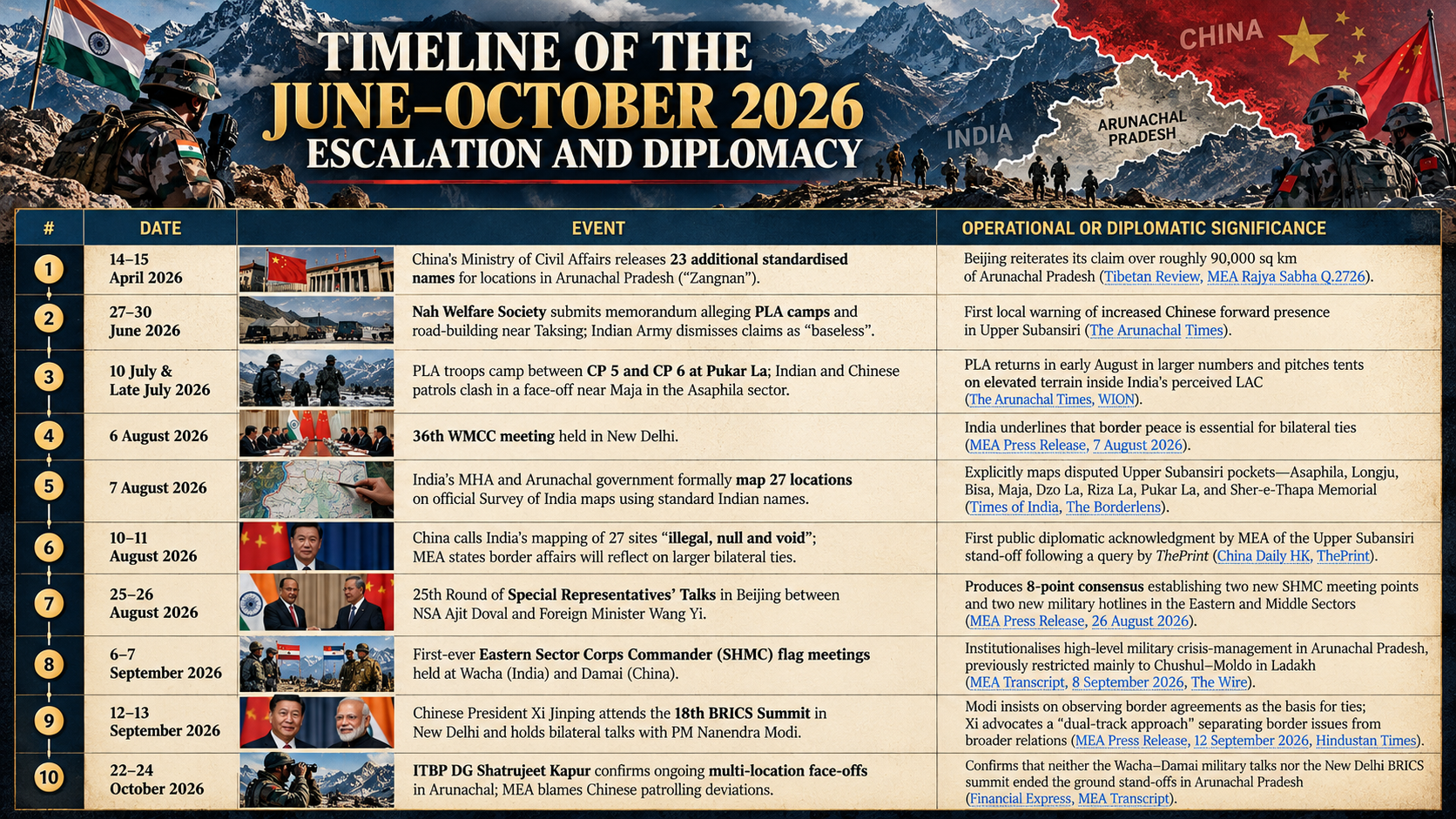
Two aspects of this sequence stand out. First, India's 7 August 2026 decision to place 27 standardised place names on official Survey of India maps was directly tied to the ground friction in Upper Subansiri. Rather than selecting random towns across Arunachal Pradesh, the Ministry of Home Affairs deliberately gazetted the exact contested pockets in Upper Subansiri—Asaphila, Longju, Bisa, Maja, Dzo La, Riza La, and Pukar La—alongside Tawang flashpoints (Tulung La and Yangtse) and the 1962 Sher-e-Thapa Memorial near Gelemo (Times of India, The Borderlens). By placing these specific pockets onto Survey of India sheets just days after the late-July Maja confrontation, New Delhi created a formal cartographic record to counter Chinese claims during the subsequent WMCC and Special Representatives' talks.
Second, the persistence of the Taksing and Asaphila stand-offs after the 6–7 September Wacha–Damai Corps Commander talks and the 12 September Modi–Xi meeting in New Delhi highlights a fundamental strategic divergence. During the BRICS summit bilateral, Prime Minister Modi emphasised that "peace and tranquility in the border areas remains an essential basis for the continued development of bilateral relations" and urged adherence to existing border agreements (MEA Press Release, 12 September 2026). President Xi, by contrast, argued for a "dual-track approach" that compartmentalises boundary friction from trade, investment, and multilateral cooperation (Hindustan Times).
That dual-track dynamic has fuelled sharp domestic political criticism inside India. On 23 October 2026, Congress general secretary Jairam Ramesh and party spokesperson Pawan Khera accused the government of maintaining a "deafening silence" over the loss of patrolling access in Arunachal Pradesh while allowing India's bilateral trade deficit with China to reach a record ₹10.64 lakh crore ($112 billion to $113 billion at the October 2026 exchange rate of approximately ₹95 per US dollar) in 2025–26, up from ₹9.41 lakh crore ($99 billion) the previous year (The Wire, Times of India, Wise). Opposition leaders also pointed to Beijing's export restrictions on heavy tunnel-boring machinery needed for Indian Himalayan infrastructure and China's planned 60,000 MW hydropower dam on the Yarlung Tsangpo (which becomes the Siang and Brahmaputra in Arunachal Pradesh and Assam) as evidence that summit-level bonhomie has not altered Beijing's coercive leverage (Hindustan Times, The Wire).
What to Watch as the Winter Window Closes
The immediate test for Indian border management in Upper Subansiri arrives in November 2026, when heavy winter snow begins to close the high-altitude foot trails above Taksing, Maja, and Gelemo.
If PLA units retain their elevated tent positions near Maja or between CP 5 and CP 6 at Pukar La through the winter months while Indian patrols scale back during the November–March snow window, temporary summer encampments risk hardening into permanent de facto buffer zones—repeating the pattern that local residents and the PPA fact-finding committee allege occurred at Shera-5 after 2023 (The Arunachal Times, WION). Conversely, maintaining year-round Indian counter-deployments at altitudes above 4,000 metres in Upper Subansiri will test the exact capabilities ITBP Director General Shatrujeet Kapur highlighted on 22 October: heated underground shelters, drone-based surveillance platoons, and all-weather road links from Nacho to Taksing and Gelemo (WION, The Arunachal Times).
The creation of the Wacha–Damai Senior Highest Military Commander mechanism and new Eastern Sector hotlines in August and September 2026 gives both armies a dedicated channel to prevent patrol encounters from escalating into lethal clashes (MEA Press Release, 26 August 2026). Yet as the ongoing face-offs in Arunachal Pradesh demonstrate, communication mechanisms only manage friction; they do not stop Beijing from testing un-demarcated sectors of the Eastern Himalayas whenever infrastructure and seasonal logistics tilt in its favour.