In brief
- On 11 October 2026 the Budhi Gandaki River swept away 35 to 40 homes, severed suspension bridges and damaged the 341 megawatt Budhi Gandaki hydro camp, marking the third major flash flood in Nepal in under two months.
- The floods stem from rapid high altitude warming that melts permafrost, intensified monsoon cloudbursts dumping 100 to 300 millimetres of rain, deep seated 2015 earthquake fractures, and unengineered dirt roads that channel water onto unstable slopes.
- Nepal has no early warning system for flash floods originating in Tibet, where automated stations and radar are virtually absent, leaving downstream communities with no alert when glaciers or landslides dam rivers.
- A moratorium on unengineered hill cutting, mandatory multi hazard zoning for hydropower, high altitude radar links with China and floodplain enforcement are urged to break the flash flood cascade.
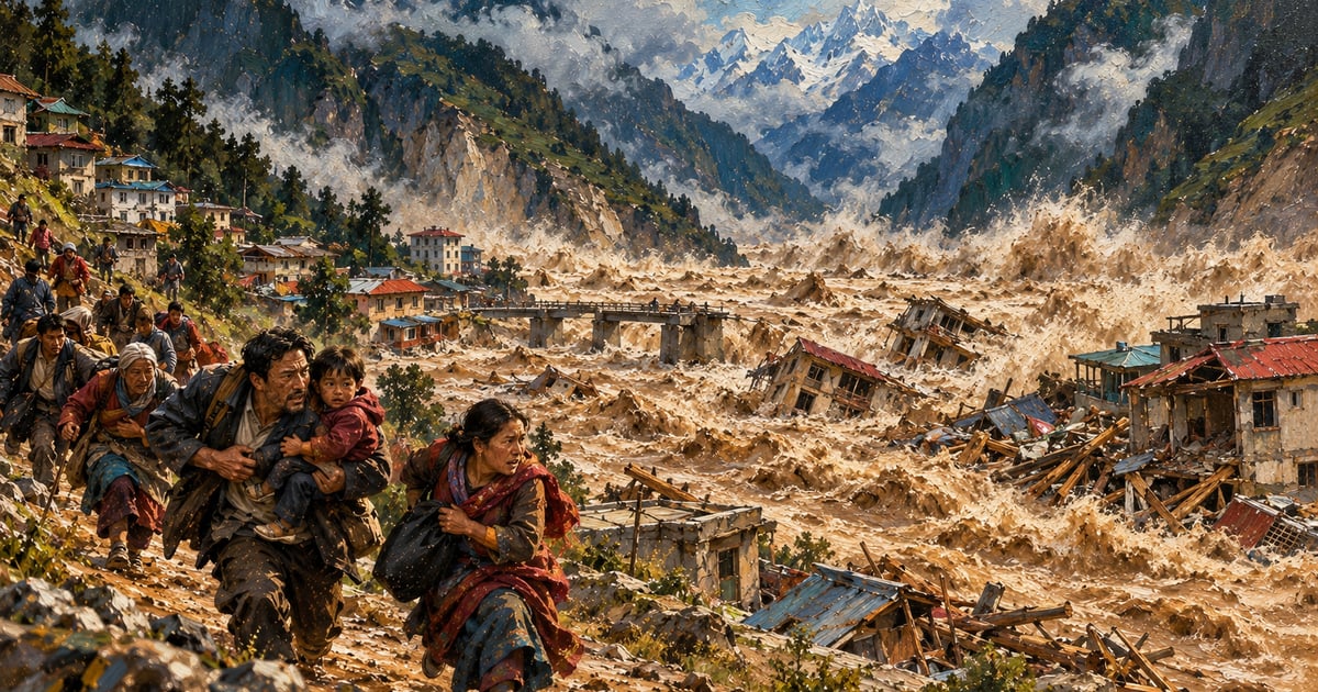
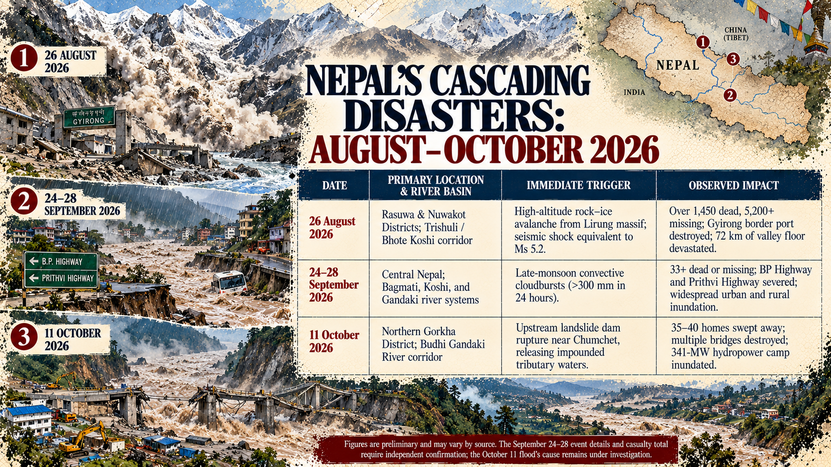
On Sunday, 11 October 2026, the Budhi Gandaki River surged through the high valleys of northern Gorkha District. Within hours, the torrent swept away between 35 and 40 homes in Chumnubri Rural Municipality, severed vital suspension bridges connecting remote settlements, and battered the construction camp of the 341-megawatt Budhi Gandaki hydroelectric project, according to reporting by The Kathmandu Post.
For Nepal, this was not an isolated seasonal hazard. It was the third catastrophic flash flood to tear through the country’s central river corridors in less than two months.
On 26 August, a colossal rock-and-ice avalanche from the Langtang range collapsed into the Bhote Koshi and Trishuli valleys, obliterating the Gyirong border crossing with China and scouring settlements along a 72-kilometre corridor. Over 1,450 people were confirmed dead, and more than 5,200 remained missing, with the disaster catalogued by the US Geological Survey (USGS) as one of the most violent mass-wasting events in modern Himalayan history. Just four weeks later, between 24 and 28 September, intense late-monsoon rainstorms triggered nationwide river swells and landslides, killing dozens and severing major highways linking the capital to the rest of the country.
The relentless tempo of these disasters has prompted an urgent question across South Asia: why is Nepal suddenly experiencing one devastating flash flood after another?
The answer is neither bad luck nor simple seasonal weather. Nepal is caught in the grip of a cascading multi-hazard cycle where warming high-altitude ice, erratic monsoon mechanics, fractured mountain geology, and reckless road-building feed directly into one another.
1. High-Altitude Destabilisation: Melting the Himalayan "Glue"
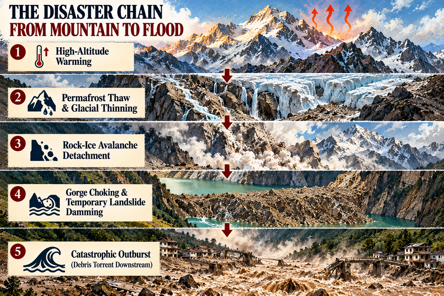
To understand why water moves with such violence through Nepal’s river corridors, one must look at the mountain tops. The Hindu Kush Himalaya is warming at two to three times the global average rate, a phenomenon known as elevation-dependent warming.
This sustained heat degrades high-altitude permafrost—the sub-surface frozen ground and ice that acts as structural mortar holding steep rock faces together. When that thermal cement melts, mountain walls lose their stability.
As glaciologists documented following the August 2026 disaster on AntarcticGlaciers.org and in expert briefings through the Science Media Centre, the disaster in Rasuwa was not caused by overflowing riverbanks. It began when a hanging glacier and massive slab of bedrock detached from high on the mountain, impacting the valley floor with the force of a magnitude 4 earthquake.
When millions of tonnes of ice and rock pulverise upon impact, frictional heat melts the ice instantly. The resulting slurry behaves like wet concrete. It does not flow like ordinary floodwater; it charges down narrow V-shaped gorges at highway speeds, picking up gravel, boulders, and soil.
This process closely mirrors the devastating 2021 Melamchi disaster, analysed in depth by ICIMOD researchers, and the August 2024 Thame flood in the Everest region, detailed by ICIMOD's glaciological assessment. What locals experience as a sudden river flood miles downstream often begins as a massive cryospheric structural failure at 6,000 metres above sea level.
2. Atmospheric Compression: Cloudbursts Replace Steady Rains
While the cryosphere primes the highest elevations for collapse, changes in the South Asian monsoon are supercharging the middle elevations.
Climate physics dictates that for every 1°C rise in atmospheric temperature, air can hold roughly 7% more water vapour—a physical law known as the Clausius-Clapeyron relation. In the Himalayas, this extra moisture does not fall as steady, soaking showers spread over four months. Instead, the monsoon is becoming compressed into erratic, highly concentrated convective downpours, commonly termed cloudbursts.
As ICIMOD noted in regional assessments, a below-normal total monsoon does not translate to a safe monsoon. When moist air currents from the Bay of Bengal slam into the sheer southern face of the Himalayas, orographic lifting forces the air upwards, generating towering storm clouds that dump 100 to 300 millimetres of rain within a few hours over a single catchment.
Mountain topsoils cannot absorb water at that rate. Surface runoff spikes instantly, transforming shallow creeks into thundering torrents within minutes. Compounding the danger, the monsoon retreat across northern South Asia has steadily delayed into late September and October, prolonging the season of saturated hillslopes well past traditional safety windows.
3. Tectonic Fractures: The Lasting Scars of 2015
Nepal's geography is fundamentally unstable by nature. The country straddles the active tectonic fault where the Indian plate subducts beneath the Eurasian plate at roughly 4 to 5 centimetres every year. The mountain chain is young, steep, and constantly rising.
Crucially, the Himalayan bedrock remains deeply compromised from the 7.8-magnitude Gorkha earthquake of 2015. The seismic shock created millions of sub-surface micro-fractures throughout central Nepal's metamorphic rock layers.
A decade later, those fractures remain permeable pathways for rainwater. When heavy downpours penetrate deep into fractured gneiss and schist, pore water pressure builds up until entire hillsides shear off. The 11 October disaster in Gorkha—the epicentre of the 2015 earthquake—illustrates this structural vulnerability: initial assessments by Nepal's Department of Hydrology and Meteorology suggest a massive hillside slip blocked a high-altitude tributary before giving way in a sudden surge.
4. "Dozer Development": The Man-Made Debris Multiplier
Climate and geology explain why water and rock fall; governance and infrastructure explain why the devastation is so extreme.
Across Nepal's 753 local local government units, the construction of unpaved rural roads has exploded over the past fifteen years. Locally termed "dozer development," these tracks are routinely cut by private excavators without geological surveys, slope stabilisation, retaining walls, or proper culvert drainage.
When heavy rain falls, these unpaved road networks act as artificial drainage channels, collecting surface water and directing it directly onto unstable slopes. The excavated debris, discarded down the hillside during construction, sits waiting for the next downpour. When a flood begins, the torrent sweeps up thousands of tonnes of loose human-dumped spoil, dramatically increasing the density and destructive impact of the river.
Furthermore, rapid and unplanned settlement on historical floodplains has placed thousands of families directly in harm's way. Riverside land, traditionally avoided by older mountain communities, has been occupied by markets, informal housing, and workers' camps for the country's booming hydroelectric sector. In Salleri on 11 October, the floodwaters directly inundated the base camp and heavy machinery of the 341-MW Budhi Gandaki hydroelectric project.
5. The Transboundary Warning Blind Spot
The final systemic vulnerability is operational: Nepal lacks the early-warning apparatus to detect flash floods before they strike.
The headwaters of Nepal's major northern river systems—including the Trishuli, Bhote Koshi, and Arun—originate on the Tibetan Plateau under Chinese administration. In these high, desolate reaches, automated meteorological stations and weather radar coverage are virtually nonexistent.
When a hanging glacier shears off or a landslide dams a glacial river inside Tibet or in an inaccessible border canyon, downstream communities in Nepal have no warning. As the Science Media Centre highlighted following the August event, the debris flow reached settlements along the Trishuli corridor in a matter of minutes to an hour.
Without automated, real-time hydrometric warning arrays and institutionalised transboundary data exchange between Beijing, Kathmandu, and New Delhi, mountain communities remain completely blind to what is gathering momentum just miles above their heads.
What Must Change: Breaking the Cascade
Halting global climate change requires international action, but mitigating Nepal’s flash flood crisis requires immediate domestic and regional reforms:
A Moratorium on Unengineered Hill Cutting: Local governments must mandate professional geotechnical assessments and standard culvert drainage for all rural road projects, halting unregulated excavator use.
Mandatory Multi-Hazard Zoning for Hydropower: Nepal's energy sector cannot continue building run-of-the-river infrastructure in narrow gorges without accounting for upstream glacial and landslide-dam risks.
High-Altitude Radar and Transboundary Data Pipelines: Establishing real-time satellite radar monitoring and direct hydrological telemetry between China and Nepal to provide downstream valleys with critical 30- to 60-minute evacuation windows.
Floodplain Demarcation and Enforcement: Strictly clearing permanent dwellings and labour camps from active river floodplains and historical breach channels.
Until these measures are taken, Nepal's rivers will continue to run not just with seasonal water, but with the collapsing fabric of the Himalayas themselves.